How To Read a Map
GPS Is Not Infallible
Knowing how to read a map is still a useful and valuable skill, current electronic technology notwithstanding. Funny thing about maps--besides the impossibility of re-folding them correctly--they are one of the oldest navigation tools around, and yet, still some of the newest. New types are always being developed. In spite of all the modern electronic gizmos that abound, I doubt that paper maps will ever be entirely replaced. They are just too convenient and too much fun.
With a GPS device, you are surely routed correctly to your destination. However, that routing does not show you anything of the surrounding area, and it is not always the best or most direct route. More than once I've had my GPS throw me into what amounted to a giant U-turn to get somewhere.
One time, we were trying to get from a friend's house in Sacramento to a business across town. We were sent up one street, down 2 blocks, over another street; left turns, right turns, and in the end, the final turn toward our destination was onto a street that was just around the corner from our friend's house, and which we could have accessed much more directly and saved about 10 minutes extra driving time. At the price of gas these days, that's a significant error.
Had we had a paper map, however, we could have laid it out, pinpointed our current location and the business' location all at the same time, and visually seen and plotted the route that would have been the most direct.
Armchair Travel
With a paper map, you can meander all over the place, and often spot places you did not know about that may catch your interest. You can then plan a route to include these points of interest for your vacation. (The same technique can be used on the new 'stay-cations' currently in vogue.)
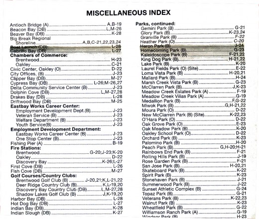
Most paper maps have on their reverse sides, in addition to a list of streets, a section of points of interest. This can include parks, monuments, historical markers and civic centers. A few swipes of a highlighter pen, and you can easily spot the ones in which you are interested, note the map coordinates, and flip the map over to start plotting your travels, imaginary or otherwise.
That same highlighter pen can mark your route, and just for grins and giggles, other colors can be used to plot side-trips or return trips via alternate route.
Miscellaneous Index
Fixing Errors in Your Plan
If you use ordinary highlighter pens, most are fairly impervious to water, and they cannot be erased with either a pencil or ink eraser without damage to the paper.
However, there is a trick I learned years back, while standing at the counter at the auto club, and watching them plot a travel route for me: I noticed the clerks all had small bottles with droppers, and blotter paper.
If they made a mistake with the highlighter, a single drop from the little bottle, a quick blot, and the boo-boo was all gone. The paper did not get wet enough to cause problems, and my nose told me what they were using was a diluted solution of ordinary bleach. Voila! Liquid eraser for a medium not erasable by normal means.
Which Way Is Up?
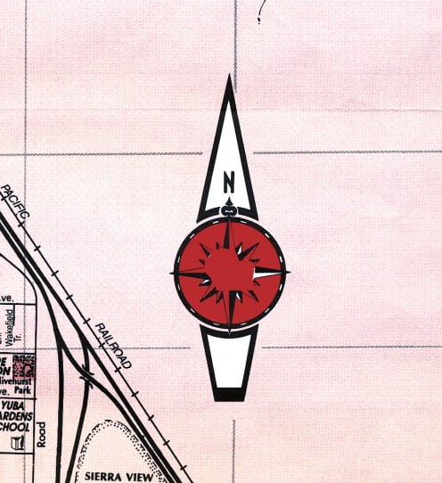
The standard protocol for maps is that north is at the top of the page. So, if you are holding the map right-side-up, so you can read the printing, you will find north somewhere toward the top of the page. Depending upon the orientation of the particular area, it could be indicated off to a slight angle to one side or the other, but will never, ever be at the bottom of the page.
(I speak only for the Northern Hemisphere--I have never been in the Southern Hemisphere, nor have I seen any maps published there, so I do not know if their maps use north or south as the main compass point of reference.)
You will easily find the 'north' marker--it will be the largest item in a 'clear' area of the map, such as an ocean if the map includes a coastal area, or simply off to the side of the area shown on the map if it is anywhere else with land on both sides.
This marker is called a 'compass rose,' and is usually a fairly ornate design with a large letter "N" to mark north.
Compass Rose
The Scale Map Tool
Also in the clearest area, near the margins of the map, will be a scale. This is a bar a few inches in length, and it tells you the scale of the map. That is, how many inches on the map indicate a mile or number of miles. Some maps also include kilometers. This is a very useful tool, as you can use it to judge how long a given trip will take.
If the scale of the map is quite large, You will find that it may be an inch or two to represent one mile, so in just looking at the map, your destination may appear to be a long distance away from your start point. But by referring to the scale, (often titled as 'scale of miles'), you will readily see that in fact, the 2 inches or so on the map, is really only a mile, and not far at all.
Conversely, sometimes maps have a small scale, if the mapmaker wanted to fit a lot into a particular map. In that case, you may find that an inch, or even a half inch, represents something like 5 or 10 miles. Now you have the reverse perception: your destination looks quite close, but upon measuring by the scale, you find that you have 15 or 20 miles or more of travel.
By using some simple arithmetic, you can also use this to approximate how long it will take to reach your destination. First, figure out the number of miles by the scale, then, divide that by your estimated average driving speed. The number you come up with in your answer is how many hours (or fraction thereof) it will take to get where you're going.
Map Scale

The Legend Map Tool
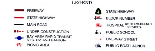
Somewhere near the scale or the compass rose will be the legend, or key. This is like a mini-dictionary of all the symbols used on that particular map. It will most often show what different types of roads you will encounter by means of varying thicknesses of the lines indicating the road.
Major highways are normally shown by double lines with shading between. Secondary roads are a single line, and city streets are a thinner single line. Railroad tracks are shown using a thin line crossed at 90 degrees by hash lines--rather like the sort of thing you'd use to imitate stitches on the Frankenstein monster for Halloween. ;-)
The legend will also show various types of markers used to pinpoint things such as schools, campgrounds or historical markers. Not all maps use all symbols. Generally speaking, the larger the scale of the map, that is, the less of a geographic area it shows, the more detailed the legend will be.
Map Legend or Key
The Map Grid
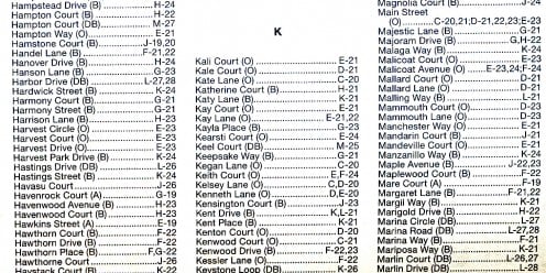
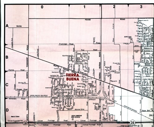
Once you have familiarized yourself with all the markings used on maps, it is time to locate your destination. This is done by means of a grid. The map is divided into squares, and those squares are referenced as rows and columns, bearing numbers for one and letters for the other.
These designations will appear in bars along the outer edges of the map, acting as a picture frame, if you will, and will be duplicated opposite each other. Let's use the illustration below for our example.
Street Index
Using the Grid
Suppose you have looked at the locations list on the back, and seen a reference of "C-1" for the location you wish to visit.
Turn the map over, and locate the row or column with the letter "C," then locate the numeral "1" at 90 degrees from the letter bars.
Run one finger down the numeral "1" column, and with the other hand, run a finger across the letter "C" row.
The point at which your fingers meet is one of the squares into which the map is divided. Your destination is somewhere within that square.
(See the example below.)
The Layout
Educational and Fun
Map reading is a very useful skill, as well as interesting and educational. By having the kids help you plot your vacation or weekend trips, for example, they will be learning a bit of geography, either local or national or both in the process.
Don't tell them that, though--always just let them think they're having fun on a great adventure! Learning should always be fun.
Related Hubs
© 2010 Liz Elias


